I got into ecology to be a conservationist, so my heart goes out to pretty much all negative effects of land use/land cover change (LU/LCC). That being said, it’s also exactly why I have to be smart about where I put my efforts and focus my attention, if only in vain to save myself a little heartache. Otherwise, I’d face even worse sadness that already comes with being an ecologist and getting daily news about just how bad our actions on this planet could be for so many, especially the poor who depend on the land and the animal life. While I have my pet concerns and “favorite ecosystems” among the myriad, the reason I’m writing about this is a because this is the first local land conservation effort I’ve ever wanted to organize. As stated above, “first” is not because I’m indifferent nor ignorant; quite the opposite! It’s because I think it’s that important, that special, and that feasible.
Here’s why: as I mentioned, I went to McGregor Marsh to hear my lifer yellow rails this spring. There isn’t much land of that large of an extent that looks like that anymore, and the proof is in the pudding: this is the best place in the entire state to find yellow rails, a species already threatened and of a seemingly very small population already at this location. The rails were in a really nice large tract of sedge meadow, which has become a much rarer ecosystem thanks to the land development of the Midwest.
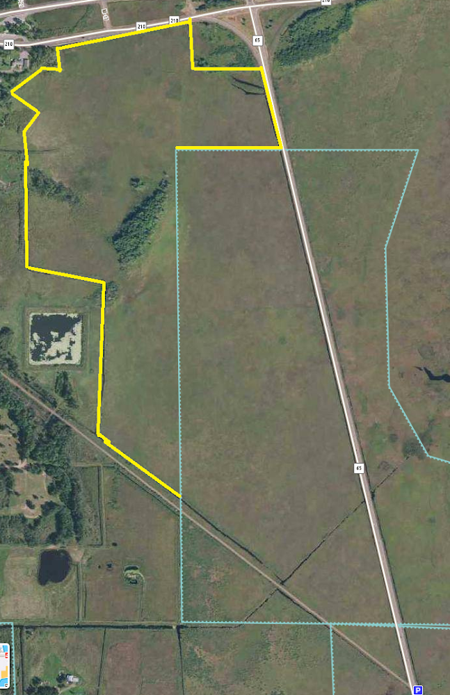
The joyousness of this occasion was somewhat dampened by the large real estate ad we saw on the north end of the tract, which led us to look into what part of this land is actually protected. Looking at the official property map of the state-owned land, here are the potential problems I see…
- the delineated parcel of the scientific & natural area (SNA) isn’t where the rails are, and it appears to be a different land cover than what’s on the west side of the road (i.e. perhaps not suitable for rails, at least what I can see closest to the highway)
- the rails are instead on the west side of Hwy 65
- the land nearest the road is DNR Forestry land (is that also technically part of the SNA and just poorly mapped?)
- the conservation opportunity: look at all the “blank space” south of Hwy 210: apparently that’s all for sale
It would be shame if a parcel like this was developed! If the land was bought and developed, what would happen? Would the public land on the west side of the road even be enough to sustain the small local yellow rail population? If it’s commercial property, who knows what would go in there, and what noise pollution effects it might have on an already hushed species.
Works cited
Kim R. Eckert. (2002) A birders’ guide to Minnesota. 4th ed.